As the transit industry struggles with declining ridership nationally, a new emphasis emerges on how to improve the “user” experience with the latest and greatest app. Riders’ smartphones are littered with an assortment of transit applications. These apps connect us to various rideshare, ride-hailing, bikeshare, mobile ticketing, and navigation services that help us move about our cities or new ones we’re exploring.
The ubiquity of transit and trip planning applications has demonstrated its utility in attracting new riders to unfamiliar transit systems. I can personally attest to this, as I first started commuting by transit during graduate school thanks to my school’s transit app. Up-to-the-minute bus arrival information enabled me to confidently navigate the city’s transit system and ensure that I wouldn’t miss an 8 am final exam.
Although apps are useful for navigating new transit systems and trip planning, their utility drops dramatically for a regular commuter. A habitual transit rider already knows where her trip begins and ends, and she seldom needs an app to tell her which bus stop to use. Daily commuters run on autopilot. A recent New Yorker article wrote that a subway rider’s “commute is worn so deeply into them that, typically, their bodies jerk awake before they miss their stops.”1 For these transit addicts, taking out a smartphone for real-time arrival information is an unnecessary step that breaks up the natural flow of navigating a city.
Smartphone dependency also raises questions about accessibility and equity. Many transit-dependent riders only have access to the static information that is printed on signage and brochures in the physical world. Although 77% of Americans now own a smartphone2, transit ridership surveys paint a different picture. The 2016 Los Angeles Metro Ridership Survey found that only 51% of its riders owned a smartphone3 – so half of the bus riders in Los Angeles get no benefit from the ecosystem of real-time apps.
Now consider passenger safety. While waiting at a bus stop late at night, would you want to pull your phone out to get the next bus arrival prediction, or would you rather keep your eyes up and see that real-time information in front of you, at a well-lit bus stop?
The solution is to present real-time information in the physical world. Think about the way that you navigate an airport. Do you ever have to use our smartphone to check which gate your flight is leaving from, or where you need to walk in order to locate the airport exit? The use of a phone isn’t necessary, because all the relevant wayfinding, gate and flight status information that you need is placed strategically in physical space. Improving communication in the real world will improve the transit user experience of our cities and make them more accessible for all.
This whole process begins at the bus stop and on the bus. We often think of a transit stop as separate from all other modes or destinations, merely as a “pass-through” point that is primarily something else – a sidewalk, a mall, etc. What if instead we thought about them as reference points for how to navigate a city?
By using the same technology that powers all of the great trip planning apps—third party data sources and APIs—we can leverage that data to provide valuable information to all riders, in the physical world.
We can imagine what this would look like.
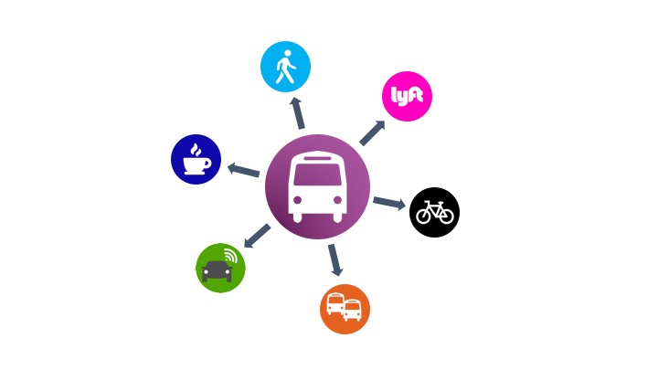
Real-time signage that displays not only bus arrivals, but also:
• Real-time information from all operators or agencies who may share stops;
• Walking duration to popular destinations;
• Nearby bikeshare availability;
• Arrival estimates for ride-hailing services;
• Real-time transit vehicle seating availability4.
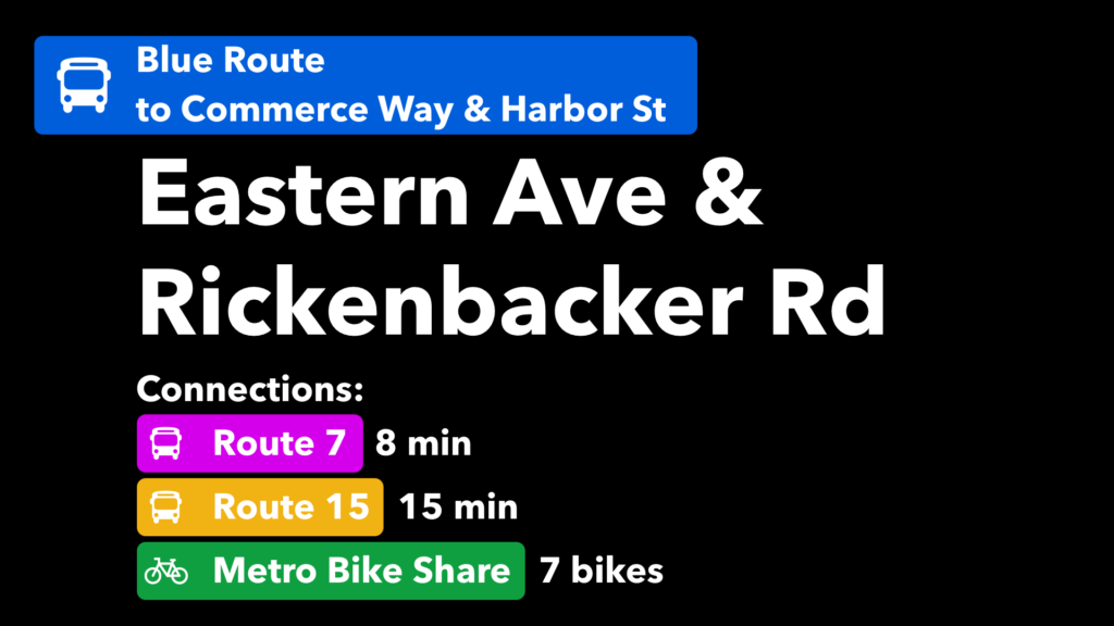
We can also display pertinent first/last mile connection information on board using “infotainment” screens, including:
• Real-time arrival information for upcoming stops, and arrival predictions of connecting buses;
• Availability of additional mobility services at these stops (bike share, car share, hoverboard share?);
• Service alerts;
• Contextual advertisements that display when passing by the local coffee shop or grocery store.
The transit stop is no longer just a start and end point for someone riding the system, but rather, an integral part of the rider’s experience. Rethinking the use of physical space, and how we can present useful, contextual, and real-time information in that physical space will have a transformational impact on how we move about our cities.

© CoMotion LA │ Powering a Sustainable Multimodal Future for All
Sign up for CoMotion NEWS, our must-read weekly newsletter that contains the most critical mobility news of the week, updates about: CoMotion events, the Fast Forward Podcast and more!